McDowell Creek Park Waterfalls
Photographer/Videographer: G. Price
Return to Lebanon/Sweethome
Home Page
GPS Royal Terrace, Lower McDowell lower parking area
GPS Majestic Falls upper parking area
Royal Terrace Falls - February high flow 1.7MB 7S 480p
Lwr McDowell Crk Falls - February high flow 3.2MB 8S 480p
Majestic Falls in ethereal fog December 1.6MB 720p
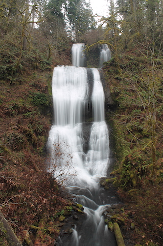
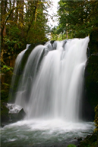
Royal Terrace / Lower McDowell Creek and Majestic Falls, Elevation above sea level 280m and 300m.
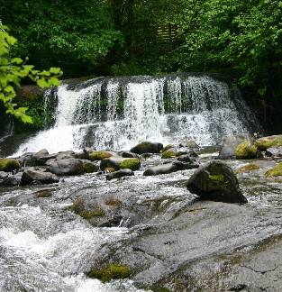
Lower McDowell Creek Falls
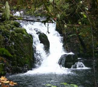
Crystal Pool Falls
McDowell Creek Park is east of Lebanon
Four waterfalls are linked to a common trail split by a paved road.
Total hiking distance < 1 mile.
- Lower McDowell Creek Falls
- Royal Terrace Falls
- Crystal Pool Falls
- Majestic Falls
Directions:
- From I-5 exit onto Hwy 20 and head east towards Lebanon
- Four miles east of Lebanon turn left onto Fairview road and
bear right at the T-junction (road to McDowell Creek Park)
- Appr. 0.9 miles bear left to stay on McDowell Creek road
- Another 7.6 miles turn right into the parking area for McDowell Creek Park
Path starts at end of parking area. Lower McDowell Creek Falls
is visible as you cross the bridge (face on views are available near
the picnic tables). Crossing the bridge, the path leads to Royal Terrace Falls
in less than half a mile. Following the path away from this
waterfall will eventually lead to a paved road in appr. 0.3 mile. Cross this
road and link up with the remainder of the path. It will lead to Crystal Pool
Falls and farther up will be Majestic Falls.
Some paths have staircases - tread carefully.
Vault toilet available at parking area.
Note: each waterfall has an individual parking area.
For Majestic Falls it may be easier to drive up to the third
parking space. Caution: a short section of the road may
need to be driven in low gear.
URL: https://oregonwaterfalls.net/mcreekf.htm